Old Trolley Tracks (Somerville Ave)
[Category: Historical infrastructure dorkery]
I actually took the car to work on Tuesday; as I headed away from Mass Ave at Porter onto Somerville Ave, I saw that they had a few lanes blocked for construction. Ugh... seems like they've been doing repeated construction for years now on Somerville Ave.
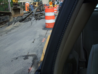
But as I stopped at the light, I saw them ripping up... whoah... what's that?

Huh... looked like there were trolley lines under the asphalt that they were tearing up. At first, I thought they might have done this by accident: Okay guys, let's just get the backhoe in here, and we'll make a hole for the gas lin... aw, crap, what did we snag here?
But if you look a bit more closely, they have the trolley location marked with white dashed paint (apologies for the composition of the photos; they were taken blind pointing my camera behind me out the passenger window). Note how the track was poking up through the asphalt at the double yellow line--y'know, I think I remember seeing that, and wondering what it was...

Anyway, I had no idea that there used to be a trolley line here (parallel with the commuter rail tracks). But that seems to be the case, according to this Boston streetcar map from Wikipedia. Also, there is a 323 page PDF of "Changes to Transit Service in the MBTA district" on the web:
June 1, 1912 The Lechmere viaduct opened from the North Station portal to Lechmere Sq. An elevated station was located at North Station West. Surface car lines operating through from Clarendon Hill via Somerville Ave., Clarendon Hill via Highland Ave., and Harvard Sq. via Cambridge St. operated over the viaduct to Scollay Sq. or to the portal at Tremont & Broadway.
Huh... it all pretty much makes sense. However, if you ever see me compelled to write a 323 page document about a transit system, you might want to stage an intervention.


1 Comments:
Yeah, that sounds like something William James Sidis would have written. --Omri
Post a Comment
<< Home